We will help businesses increase their revenue on average and approximately by 80% in their first year with us by adapting with Future Learning Solutions!!
5k
Our FLS Prediction
60%
Prediction esttimated on SUCCESS RATE
100
Prediction of HAPPY CLIENTS
1030
Our prediction of CUPS OF COFFEE
Future Learning Solutions NV
It is a long established fact that a reader will be distracted by the readable content of a page when looking at its layout.

You choose Us to be more creative.
You choose Us to have more PERFORMANCE
You choose Us to adapt knowledge and apply it the right way!
You are Upgrading with US.
CIVIL 3D AND 3D ARCHITECTURE WITH AUTOCAD AND PROJECT MANAGEMENT (CIVAR ELITE PROGRAM)
Managing the construction process, ensuring that all parties involved are aware of their responsibilities and that the project stays on track. Effective communication and coordination between contractors, engineers, etc..
Curriculum modules
Accredited by Autodesk
Course duration : 1 year or 12 months
Full Online 2 times a week with sessions of 1 hour.
Course Price : USD 1000

Building Materials
Construction Technology
Structural Design
Surveying and Site Planning
Safety and Health

AUTOCAD 3D FUNDAMENTALS
Managing the construction process, ensuring that all parties involved are aware of their responsibilities and that the project stays on track. Effective communication and coordination between contractors, engineers, etc..
Curriculum modules
Accredited by Autodesk
Course duration : 8 weeks or 2 months
Full Online 1 times a week with sessions of 1 hour.
Course Price : USD 100
Discover basic interface
Navigation in 3D within AutoCAD
Navigation in 3D within AutoCAD
Creation of 3D solids
Learn how to view your 3D model with view styles

AUTOCAD CIVIL 3D
AutoCAD Civil 3D is specialized civil engineering design and documentation software. It's an extension of AutoCAD, offering tools for infrastructure projects like roads, railways, and subdivisions. Key features include terrain modeling, corridor design, intersection design, and plan production. Civil 3D helps civil engineers streamline workflows, improve design coordination, and create accurate construction documentation.
Curriculum modules
Accredited by Autodesk
Course duration : 24 weeks or 6 months
Full Online 1-2 times a week with sessions of 1 hour.
Benefits for Civil Engineers:
Improved Design Decisions:
The model-based environment and design-driven approach help engineers make better decisions and improve project quality.
Streamlined Documentation:
Civil 3D automates the creation of construction documentation, saving time and reducing errors.
Enhanced Collaboration:
The software facilitates better design coordination and collaboration among project teams.
Efficient Workflows:
By automating many tasks and providing specialized tools, Civil 3D helps civil engineers work more efficientl
Course Price : USD 800
Site and Survey Workflows
Terrain Modeling,
Plan Production,
Documentation
Pressure Networks,
Interoperability
Corridor Modeling
Intersection Design
Drainage Design and Analysis

AUTOCAD MECHANICAL (Basics)
AutoCAD Mechanical is a specialized version of AutoCAD, designed for mechanical engineering professionals. It includes a comprehensive set of tools and features specifically tailored for mechanical design, drafting, and documentation. These tools streamline the creation of mechanical designs, automate tasks, and enhance overall productivity.
Curriculum modules
Accredited by Autodesk
Course duration : 16 weeks or 4 months
Full Online 1-2 times a week with sessions of 1 hour.
introductory concepts
drawing and editing tools
mechanical parts generators
drawing sheets
dimensioning and annotating
and file management
Course Price : USD 600
introductory concepts
drawing and editing tools
mechanical parts generators
drawing sheets,
dimensioning and annotating
file management

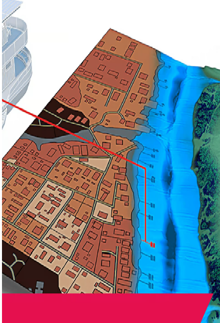
AUTOCAD MAP 3D (Basics)
• Work with multiple coordinate systems
• Clean drawings with common geometry errors
• Work with COGO tools to accurately map objects
• Insert rectified raster images
• Work with a variety of attribute data
• Apply object classification to your mapping system
• Import GIS data from a variety of sources
• Export geometry and attribute data to other GIS formats
• Connect directly to GIS data and stylize features
• Access Data using the Autodesk Connector for ArcGIS
• Connect to raster surface data and raster images
• Attach and query source drawings
• Save changes to attached source drawings
• Extract data for reports and quantity takeoffs
• Create, manage and analyze topologies
• Create dynamic scale bars, north arrows and legends
• Produce map books to automate sheet layout
Curriculum modules
Accredited by Autodesk
Course duration : 12 weeks or 3 months
Full Online 1-2 times a week with sessions of 1 hour.
•Creating & Editing Geometry
•Linking & Managing Attribute Data
•Using Object Classification
•Importing & Exporting Drawing-based Data
•Establishing a Geospatial Environment
•Editing Features
•Working with Raster Images
•Working with Source Drawings
•Using Source Drawing Queries
•Stylizing Drawings & Features
•Plotting Maps
•Survey Data
Course Price : USD 700